Thursday, July 23, 2015

El ADN revela secretos de la primera migración a América

Dos estudios genéticos separados hallaron evidencias de un sorprendente vínculo genético entre las poblaciones nativas de las Américas y Oceanía.

El ADN de algunos nativos amazónicos muestra una semejanza significativa con los habitantes indígenas de Australia y Melanesia, el cinturón de islas que van desde el Pacífico occidental hasta Fiji.

Los dos grupos de investigación, sin embargo, hacen distintas interpretaciones de cómo fue poblada América.

Los estudios fueron publicados en las revistas Science y Nature.

Hay un consenso en que los primeros pobladores de las Américas llegaron a través de Siberia, por un puente de tierra que conectaba con Europa y Asia.

Pero no hay acuerdo sobre la procedencia de estos pobladores y en qué momento llegaron.

Al analizar el ADN de los nativos americanos modernos y de antiguos restos humanos, el grupo que escribe para Science concluye que todos los nativos americanos de la actualidad proceden de una migración única no más temprana a hace más de 23.000 años.

Entonces, alegan, hace unos 13.000 años los nativos americanos se dividieron en dos ramas: una que ahora está dispersa por América del Norte y del Sur, mientras que la otra se limita a América del Norte.

"Nuestro estudio muestra que el modelo más simple posible parece ser verdadero, con una sola y notoria excepción", le dijo a la BBC el profesor Rasmus Nielsen de la Universidad de California, Berkley.

No hay acuerdo sobre la procedencia de los pobladores de América y en qué momento llegaron.

"Así que las ideas fantasiosas de que de alguna manera América fue poblada por personas procedentes de Europa y todo tipo de lugares son erróneas".

El análisis también descarta la teoría, defendida por algunos, de una migración escalonada desde Siberia: la primera de hace más de 30.000 años que fue detenida durante 15.000 años por el hielo que bloqueaba la ruta y una segunda oleada una vez que el camino se despejó.

Pero, al igual que en el estudio de la revisa Nature, el equipo de Nielsen registró rastros de ancestros "australo-melanesios" en algunas poblaciones, incluidas aquellas de las islas Aleutianas (frente a Alaska) y la comunidad surui del Amazonas brasileño.

El profesor David Reich de la Escuela Médica de Harvard lideró el estudio de Nature.

Reich le explicó a la BBC que "ambos estudios muestran que ha habido múltiples flujos de migración hacia las Américas".

Según Reich, el descubrimiento del linaje oceánicos entre algunos grupos nativos Americanos indica que América fue poblada por una serie de grupos más diversos de lo que anteriormente se creía.

El mapa del artículo de Nature resalta la similitud entre los indígenas amazónicos y los australasianos.

"El modelo más simple posible nunca predijo una afinidad entre los amazónicos y los australasianos", señaló.

"Esto sugiere que hay una población ancestral que cruzó hacia América que es diferente de la población que dio lugar a la gran mayoría de americanos. Y esto es una gran sorpresa".

Reich cree que la explicación más plausible es que hubo una migración separada desde Australasia (región que comprende Australia, Melanesia y Nueva Zelanda), posiblemente hace unos 15.000 años.

Este grupo, considera, probablemente se dispersó más por América del Norte pero gradualmente fue expulsado por otras comunidades nativas americanas.

Por su parte, Nielsen tiene una interpretación diferente pues opina que los rastros del ADN australasiano se derivan de una migración posterior, hace unos 8.000 años, que avanzó por la costa del Pacífico.


El ADN revela secretos de la primera migración a América

Sunday, July 19, 2015

Can the U.S. Avoid Chaos In Puerto Rico?

awmakers in Washington appear to be getting increasingly anxious about the situation in Puerto Rico, which is poised to default on some $70 billion in debt the island territory has acquired over the past several years. A key concern is the impact such a default could have on U.S. bond markets.

In a letter to Treasury Secretary Jack Lew on Friday, Senate Finance Committee Chairman Orrin Hatch (R-UT) asked the administration about its plans for dealing with the island’s finances, including its opinion on a move being pushed in Congress to allow Puerto Rico’s municipalities and public utilities to file for Chapter 9 bankruptcy. Hatch’s letter came just days after two other senators, Chuck Schumer (D-NY) and Richard Blumenthal (D-CT) introduced legislation that would make those Chapter 9 filings possible.

Related: How the U.S. Is Helping Sink Puerto Rico

Two big questions right now are whether there is significant support in Congress to make such a change to bankruptcy laws and whether any such action can happen quickly enough to avoid what Hatch called a “chaotic resolution” of the crisis.

Puerto Rican municipalities and public utilities were for years allowed to issue “triple tax-free” obligations – meaning that lenders’ earnings were exempt from local, state, and federal taxation. This made Puerto Rican debt an attractive option for investors, whose eagerness to benefit from the tax exemption helped Puerto Rico cover a substantial budget deficit.

But slow economic growth has made it impossible for Puerto Rico to continue servicing its debts while providing basic services to its citizens.

“The debt is not payable,” the Island’s governor, Alejandro Garcia Padilla, warned in an interview with The New York Times last month. “There is no other option. I would love to have an easier option. This is not politics, this is math.”

Related: S&P Cuts Puerto Rico’s Debt Financing Arm, Says Default Certain

This week, with the report that the agency managing the government’s debt failed to make a deposit into a fund used to pay bondholders, the likelihood of default when those payments come due on August 1 seemed higher than ever. In his letter to Lew, Hatch made it plain where he believes the blame for the crisis lies.

“Unfortunately for residents of Puerto Rico, the Commonwealth has made unsustainable government benefit promises that have been papered over for far too long with debt-fueled expenditures which fail to align benefits with underlying economic fundamentals such as productivity, leading to the ultimate prospect of debt default,” he wrote. “Tragically, unsound financial decisions of government officials have led to a sharp rise in outmigration.”

Hatch noted that he believes there is at least some common ground between the White House and his committee on how to deal with the crisis.

Related: How Puerto Rico’s Debt Crisis Could Hurt the GOP

“I believe that the Obama administration may be in agreement with two reasonable principles to apply to the debt difficulties facing Puerto Rico: 1) there shall not be a federal bailout; and 2) orderly resolution of debt defaults are preferred to chaotic resolutions.”

Among other things, he asked for the administration’s specific thoughts on making Chapter 9 bankruptcy available to Puerto Rico’s bond issuers. He noted that a key element could be the “retroactive application” of that eligibility to existing debts – something that would likely anger creditors who could claim that the government is changing the rules in the middle of the game.

But that rule change may be the only way out, according to some in Washington. In introducing the “Puerto Rico Chapter 9 Uniformity Act” earlier this week, Sen. Blumenthal said, ““This measure is vital to prevent a humanitarian and financial catastrophe – a clearly avoidable disaster. Creditors, investors, ordinary citizens, all will be harmed if the Congress fails to act. This measure is not a bailout – involving not a dime of federal funds. It enables an orderly, rational restructuring of debt, instead of a financial free for all and potential free fall.”

Sen. Schumer added, “We can either do the right thing and give Puerto Rico the bankruptcy option it needs and deserves, or we can risk a disaster on the island and billions in bailout payments later.”

By

Can the U.S. Avoid Chaos In Puerto Rico?

Asteroid spotted in Puerto Rico awes scientists for its shape and tremendous speed

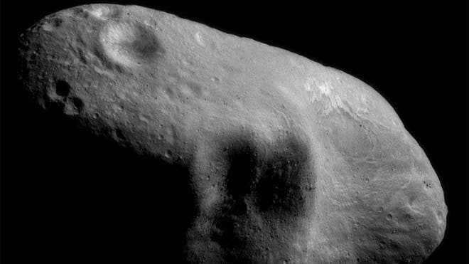
The Arecibo Observatory in Puerto Rico has announced that the first detailed images have been obtained of Asteroid 2011 UW158, which show it has a very odd shape and structure, and that it spins at a tremendous speed on its own axis, phenomena that have intrigued scientists.

The images were obtained by scientists at this Puerto Rican observatory - which has the largest, most sensitive single-dish radio telescope in the world - on Tuesday, July 14, when the asteroid passed by at some 6.9 million kilometers (4.3 million miles) from Earth, or nine time the distance from this planet to the moon.

Many of the asteroids observed up to now appear to be numerous small stones weakly held together by gravity, the observatory said in a communique.

However, Asteroid 2011 UW158 has "an odd shape much like an unshelled walnut" and with a diameter of 300 by 600 meters (1,000 by 2,000 feet), almost twice the size of the reflector of this observatory's radio telescope.

The scientists working there were also able to confirm that the asteroid "rotates very rapidly, once every 37 minutes" as in previous optical observations.

While many scientists were watching the historic flight of the New Horizons spacecraft past the dwarf planet Pluto, those at the Arecibo observatory said they were observing this object, very small and much closer, as it passed by Earth.

"We expect that something this big should have been shattered into smaller pieces by collisions with other asteroids over the age of the Solar System. It is interesting that something this large and apparently solid is still around," scientist Patrick Taylor, of the Planetary Studies Department and leader of these observations, said.

He added that this asteroid will pass relatively close to Earth again in the year 2108, but will not represent any danger.


ASTEROIDE FILE.jpg


Asteroid spotted in Puerto Rico awes scientists for its shape and tremendous speed

Saturday, July 18, 2015

After Hundreds of Years, Astronomers Finally Agree: This Is the Distance From the Earth to the Sun - The Atlantic

The International Astronomical Union drops the mic.

[optional image description]How far away from Earth is the sun? Not just, you know, very, very far, but in terms of an actual, measurable distance? When you're calculating, how do you decide which location on Earth to measure from? How do you decide which spot on the path of Earth's orbit will serve as the focal point for the measurement? How do you account for the sheer size of the sun, for the lengthy reach of its fumes and flames?
The measurable, mean distance -- also known as the astronomical number -- has been a subject of debate among astronomers since the 17th century. The first precise measurement of the Earth/sun divide, Nature notes, was made by the astronomer and engineer Giovanni Cassini in 1672. Cassini, from Paris, compared his measurements of Mars against observations recorded by his colleague Jean Richer, working from French Guiana. Combining their calculations, the astronomers were able to determine a third measurement: the distance between the Earth and the sun. The pair estimated a stretch of 87 million miles -- which is actually pretty close to the value astronomers assume today.
But their measurement wasn't, actually, a number. It was a parallax measurement, a combination of constants used to transform angular measurements into distance. Until the second half of the twentieth century -- until innovations like spacecraft, radar, and lasers gave us the tools to catch up with our ambition -- that approach to measuring the cosmos was the best we had. Until quite recently, if you were to ask an astronomer, "What's the distance between Earth and the sun?" that astronomer would be compelled to reply: "Oh, it's the radius of an unperturbed circular orbit a massless body would revolve about the sun in 2*(pi)/k days (i.e., 365.2568983.... days), where k is defined as the Gaussian constant exactly equal to 0.01720209895."

Oh, right. Of course.

But rocket science just got a little more straightforward. With little fanfare, Nature reports, the International Astronomical Union has redefined the astronomical number, once and for all -- or, at least, once and for now. According to the Union's unanimous vote, here is Earth's official, scientific, and fixed distance from the sun: 149,597,870,700 meters. Approximately 93,000,000 miles.

For astronomers, the change from complexity to fixity will mean a new convenience when they're calculating distances (not to mention explaining those distances to students and non-rocket scientists). It will mean the ability to ditch ad hoc numbers in favor of more uniform calculations. It will mean a measurement that more properly accounts for the general theory of relativity. (A meter in this case is defined as "the distance traveled by light in a vacuum in 1/299,792,458 of a second" -- and since the speed of light is constant, the astronomical unit will no longer depend on an observer's location with the solar system.) The new unit will also more accurately account for the state of the sun, which is slowly losing mass as it radiates energy. (The Gaussian constant is based on solar mass.)

So why did it take so long for the astronomy community to agree on a standard measurement? For, among other things, the same reason this story mentions both meters and miles. Tradition can be its own powerful force, and the widespread use of the old unit -- which has been in place since 1976 -- means that a new one will require changes both minor and sweeping. Calculations are based on the old unit. Computer programs are based on the old unit. Straightforwardness is not without its inconveniences.

But it's also not without its benefits. The astronomical unit serves as a basis for many of the other measures astronomers make as they attempt to understand the universe. The moon, for example, is 0.0026 ± 0.0001 AU from Earth. Venus is 0.72 ± 0.01 AU from the sun. Mars is 1.52 ± 0.04 AU from our host star. Descriptions like that -- particularly for amateurs who want to understand our world as astronomers do -- just got a little more comprehensible. And thus a little more meaningful.
Megan Garber

After Hundreds of Years, Astronomers Finally Agree: This Is the Distance From the Earth to the Sun

Wednesday, July 15, 2015

More than 7,000 sardines die in Puerto Rico reservoir from lack of water

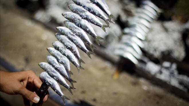
Almost 7,000 sardines have died over the last two days in a reservoir in northern Puerto Rico due to the drought that has been shrinking the water supply for two months, making this the third massive dying off of this fish species in less than two weeks.

The secretary of the Natural and Environmental Resources Department, Carmen Guerrero Perez, reported the situation Tuesday in a statement that said the fish perished in the Wildlife Refuge of La Plata Reservoir in Toa Alta.

"We ask citizens not to consume or come in contact with these dead fish, since they decompose rapidly and can put their health at risk," Guerrero said.

She recalled that access to the area was closed to the public on July 1 as a security measure because of the instability of the banks of the reservoir and the impossibility of using the boat ramp.

For her part, Wildlife Refuge manager Marinelly Valentin Sivico said that as happened twice before, the mortality was the result of less available dissolved oxygen for aquatic life due to the low level of the reservoir.

Between July 2-3, close to 8,000 sardines died off and a few days later the same disaster was repeated.

"With the reduction of oxygen in the reservoir, the most vulnerable fish are the sardines," Guerrero said.

"The purpose of these fish in the reservoir is precisely to serve and an indicator of water conditions behind our dams, while also providing recreational fishing," she said.

sardines pr.jpg

More than 7,000 sardines die in Puerto Rico reservoir from lack of water

Tuesday, April 21, 2015

Japan train sets new speed record

A Japanese magnetic levitation train has broken its own world speed record, hitting 603km/h (374mph) in a test run near Mount Fuji.

The train beat the 590km/h speed it had set last week in another test.

Maglev trains use a electrically charged magnets to lift and move carriages above the rail tracks.

Central Japan Railway (JR Central), which owns the trains, wants to introduce the service between Tokyo and the central city of Nagoya by 2027.

The 280km journey would take only about 40 minutes, less than half the current time.

However, passengers will not get to experience the maglev's record-breaking speeds because the company said its trains will operate at a maximum of 505km/h.

Construction is estimated at nearly $100bn (£67bn) just for the stretch to Nagoya, with more than 80% of the route expected to go through costly tunnels, reported AFP news agency.

The government is also hoping to sell the maglev train technology overseas.

Japanese Prime Minister Shinzo Abe is visiting the US on Sunday where he is expected to pitch for a role in building a new high-speed rail line between New York and Washington.


The Maglev (magnetic levitation) train during a test run on the experimental track in Tsuru, 100km west of Tokyo, on May 11, 2010. © Getty Images The Maglev (magnetic levitation) train during a test run on the experimental track in Tsuru, 100km west of Tokyo, on May 11, 2010.

Japan train sets new speed record

Okeanos Explorer | Expeditions | NOAA Ship Okeanos Explorer: Exploring Puerto Rico’s Seamounts, Trenches, and Troughs | Media Resources | Highlight Video and Images

Dive highlight videos, short video clips, and photos for the Océano Profundo: Exploring Puerto Rico's Seamounts, Trenches and Troughs 2015 expedition for members of the media will be posted here as they are available.

Unless otherwise noted, all videos and images posted here are in the public domain and are thus free for use and reproduction. Please credit NOAA Office of Ocean Exploration and Research.

Access LIVE video feeds here.

For videos and images associated with mission updates and logs, visit this page.


Highlight Images

Leg 3 Exploration Map

Leg 3 Exploration Map

This map shows the areas NOAA Ship Okeanos Explorer will explore during the 20 ROV dives to be conducted between April 9 and 30 in and around the Puerto Rico Trench and the U.​S.​ Virgin Islands. Data displayed provided by ESRI, Delorme, GEBCO, USGS, NOAA NGDC, and other contributors; map created with ESRI ArcMap software.


Image courtesy of the NOAA Office of Ocean Exploration and Research.

Download.


Bathymetry of Puerto Rico Trench

Bathymetry of Puerto Rico Trench

Bathymetry (underwater topography) of the northeast corner of the Caribbean Plate, including the Puerto Rico Trench, collected during a 2003 U.S. Geological Survey expedition to the Puerto Rico Trench funded by NOAA's Office of Ocean Exploration and Research. The complex bathymetry of the seafloor of this region is a consequence of plate tectonics, the theory that describes the large-scale motion of the various plates that make up the outer shell of the earth.

Image courtesy of USGS.

Download.

 
Dumbo Octopus

Dumbo Octopus

A dumbo octopus displays a body posture never before observed in cirrate octopods. Unprecedented sights like this are one of the reasons dozens of scientists (and hundreds of thousands of members of the public) follow live video from the seafloor during each Okeanos Explorer expedition.


Image courtesy of the NOAA's Office of Ocean Exploration and Research.

Download.

 
Mission Plan

Chemosynthetic Mussels

These chemosynthetic mussels were discovered by the ROV Deep Discoverer while it explored a canyon off the northeast coast of the U.S. in 2013. Over 800,000 members of the public tuned in to the video the ROV live-streamed over the internet during this expedition. Chemosynthetic mussels are found in areas of active hydrocarbon seepage; NOAA Ship Okeanos Explorer has discovered hundreds of previously unknown methane seeps in this and other areas over the past five years.

Image courtesy of the NOAA's Office of Ocean Exploration and Research.

Download.

 
Black Coral

Black Coral

During a 2014 expedition on the Ocean Exploration Trust's ship, Nautilus, to areas just off the coast of the British Virgin Islands, the ship's ROV came across this large colony of black coral. Scientists aboard NOAA Ship Okeanos Explorer hope to see similar deep-sea corals when they explore the nearby Puerto Rico Trench in April. NOAA's Office of Ocean Exploration and Research funds about half of the nonprofit Ocean Exploration Trust's operating costs.

Image courtesy of Ocean Exploration Trust.

Download.

 
ROV System Launch

ROV System Launch

Okeanos Explorer's dual-body ROV system is loaded from the aftdeck of the ship into the water before conducting an exploration dive.


Image courtesy of the NOAA's Office of Ocean Exploration and Research.

Download.

 
ROV System Launch

Control Room

The Okeanos Explorer control room just before the start of an ROV dive. The control room is where the ROV pilots, the science leads, and other expedition personnel work during an ROV dive.


Image courtesy of the NOAA's Office of Ocean Exploration and Research.

Download.


Okeanos Explorer | Expeditions | NOAA Ship Okeanos Explorer: Exploring Puerto Rico’s Seamounts, Trenches, and Troughs | Media Resources | Highlight Video and Images

Monday, April 20, 2015

Deepwater exploration vehicle prototype successfully tested in Puerto Rico

The prototype of a new deepsea exploration vehicle designed and developed in the University of Mayagüez's Electrical and Computer Engineering department labs was successfully tested, its developers said on the weekend.

The tests were carried out this past week during the scientific expedition of the vessel Okeanos Explorer, owned by the U.S. National Oceanic and Atmospheric Administration in waters just off the Puerto Rican coast.

"Two of these deployments touched the deepest point in the Puerto Rico Trench and Atlantic Ocean, one of the most extreme places on the planet and about which little information is known," said Wilford Schmidt, a professor of Marine Sciences at the Puerto Rico university and one of those in charge of the project, in a communique.

"This is the first of several excursions that we forecast will be undertaken in the Puerto Rico Trench and the Muertos Trough, south of the island," he added.

"We hope to continue obtaining data that will supply models for analysis and prediction of geological activity, planetary aquatic circulation patterns and the study of marine species, among other things," he said.

The new DMS-ECE Free-Vehicle (FV) technology is designed to serve as a means to facilitate research on the Puerto Rico Trench, the deepest trough in the entire Atlantic Ocean and the seventh-deepest in the world.

"The FV is an autonomous free-descent and -ascent vehicle with a series of instruments and sensors that allow us to obtain data about vehicular interaction and autonomy in the presence of submarine currents, pressure and temperature, among other monitored parameters," said Manuel Jimenez, a professor of Electrical and Computer Engineering and the associate dean of the Engineering Department at the University of Mayagüez. EFE

Deepwater exploration vehicle prototype successfully tested in Puerto Rico

Friday, April 17, 2015

Okeanos Explorer | Expeditions | Exploring Puerto Rico’s Seamounts, Trenches, and Troughs

Remotely operated vehicle Deep Discoverer is deployed for a dive.
Remotely operated vehicle Deep Discoverer is deployed for a dive. Image courtesy of NOAA Okeanos Explorer Program, Océano Profundo 2015: Exploring Puerto Rico’s Seamounts, Trenches, and Troughs.

Okeanos Explorer | Expeditions | Exploring Puerto Rico’s Seamounts, Trenches, and Troughs

Saturday, April 11, 2015

Discover the Puerto Rico Trench with America’s Ocean Exploration Team

Every two years people around the world suddenly obsessively watch odd niche sports like ice dancing, biathalon, and rhythmic gymnastics. So I wish similar enthusiasm could be summoned for the exploration dives of the Deep Discoverer, NOAA’s ROV aboard the research vessel Okeanos Explorer and vehicles like it, which are streamed live on the internet. Perhaps it would help if they got some catchy theme music by John Williams that played every time they fired up their feed, video interludes featuring the touching back stories of the scientists and engineers on board, or set pieces about the shenanigans that go on in the “scientists’ village” aboard the ship? Are you listening, NBC?

In any case, the Okeanos Explorer and Deep Discoverer begin their next series of 20 dives starting TODAY, April 10. As I write this, the ROV is already descending toward the bottom and has just passed 3500 meters on its way to a target depth of 4000 meters, which they expect to reach in about 15 minutes. They plan to explore the area until about 4pm EDT. As always, the dives are being streamed live on the internet and all of you can follow along at home, just as you would if you were watching a shuttle launch or moon landing in days of yore.


Thanks to the Miracle of the Internet, we can all now watch along at home every exciting minute of these voyages, and see and discover new creatures and exciting geology at virtually the same moment as mission scientists, who, as a bonus, give you a running play by play commentary. Plus, it’s all free, or rather, supported by the generosity of American taxpayers. Why not reap the benefits of our collective investment in science by joining them for the ride in high-definition video?

Here’s an example of what you might see if you are lucky. This video, which I’ve posted here before, was captured last fall in Norfolk Canyon off the east coast of the United States. It shows two attempted squid-nappings: one failed attempt by a red crab, and one squid sashimi served up for a monkfish near the end of the video (watch the upper left corner).


To get a better feel for what you might see over the course of any given day, check out several of the 5-minute daily highlight videos from the mission last fall. Here’s one I can recommend in particular, featuring cameos by Echinoblogger Chris Mah at the Smithsonian! If you can’t spend 8 hours a day watching along at home, these five-minute daily highlight reels are a great way to still feel part of the magic, and I imagine similar videos will soon be posted for this mission here.

On the docket for this voyage are the seamounts, trenches, and troughs around Puerto Rico. The Puerto Rico Trench runs for 500 miles along the north side of Puerto Rico and the Dominican Republic and plunges 5.4 miles below the surface — the deepest point in the Atlantic Ocean. The expedition will also visit the Muertos Trough to the south of the island, the Mona Channel between the Dominican Republic and Puerto Rico, and the Virgin Islands Trough to the east.


Courtesy NOAA; click image for full-sized version and source.
What might they see? Of course, no one knows for sure what’s down there. They are hopeful they will see deepwater snapper, corals, seamounts and mud volcanoes. It is also likely, based on past experience, that the expedition will find new species, see living versions of animals known only from pallid preserved specimens, and see old species displaying unknown behaviors.
On the docket for today is the Arecibo amphitheater, a little-explored escarpment northwest of San Juan. They’ll be looking for landslides and exposed rocks on the slope, along with any critters living there. The area is close to the epicenter of a magnitude 6.4 earthquake that rumbled through San Juan just after midnight on January 13, 2014. Puerto Rico has a history of earthquakes and tsunamis; an October 1918 magnitude 7.3 earthquake produced a tsunami that killed 116 people.
Tomorrow, April 11, the team plans to visit Mona Seamount northwest of Puerto Rico, an area they expect to be richly biodiverse as many seamounts are.
There will also be a Reddit Ask Me Anything on April 16 from 1-3 pm EDT featuring NOAA ocean explorer and officer Brian Kennedy; Andrea Quattrini, a U.S. Geological Survey biologist; and Mike Cheadle, a geologist from the University of Wyoming.
This expedition runs through April 30, but if you miss it, the next one will take place July through September in an even more enticing target: the Papahānaumokuākea Marine National Monument and Hawaiian Islands Humpback Whale National Marine Sanctuary in the Pacific Ocean.
Finally, if you would like to see the many amazing photos and video collected by America’s Own Ocean Exploration Team, they are all freely available here.


Jennifer FrazerAbout the Author: Jennifer Frazer is a AAAS Science Journalism Award-winning science writer. She has degrees in biology, plant pathology/mycology, and science writing, and has spent many happy hours studying life in situ. Follow on Twitter @JenniferFrazer.


The views expressed are those of the author and are not necessarily those of Scientific American.
By Jennifer Frazer

Discover the Puerto Rico Trench with America’s Ocean Exploration Team | The Artful Amoeba, Scientific American Blog Network

Wednesday, April 08, 2015

Scientists map Caribbean seafloor as part of 12-year project

U.S. scientists on Tuesday completed a nearly two-week mission to explore waters around the U.S. Virgin Islands as part of a 12-year project to map the Caribbean seafloor and help protect its reefs.

A team with the National Oceanic and Atmospheric Administration studied an area of 270 square miles (700 square kilometers), using equipment including underwater gliders and a remotely operated vehicle to help map the seafloor and locate areas where fish spawn. They focused mostly on the southern coast of St. Croix and the northwestern coast of St. Thomas.

"It's a relatively unexplored but believed to be rich ecosystem," lead researcher Tim Battista said by telephone. "We're able to map large areas that you couldn't do with just divers."

The information will be used in efforts to conserve coral reefs as well as to update navigational charts and help government officials manage and better protect fish populations.

Reefs across the Caribbean have shrunk by more than 50 percent since the 1970s, with experts blaming climate change as well as a drop in the populations of parrotfish and sea urchins.

Part of the mission focused on studying the habitat and number of deep-water snappers that have become increasingly popular with fishermen in the area, scientist Chris Taylor said. Researchers currently know very little about the status and habitat of the silk snapper, which has golden eyes and is almost iridescent pink in color, he said.

About two-thirds of the survey was conducted in deep water, in depths up to 7,500 feet (2,300 meters), researchers said.

Among the more interesting discoveries was an underwater landslide about 6 square miles (16 square kilometers) in size as well as hundreds of cylindrical sea floor structures that were packed closely together and featured hard and soft coral on top, Battista said.

"It was really kind of unique," he said. "I hadn't seen that before."

Researchers also found a collection of sea anemones in purple, green, white and black; gray sea cucumbers with stubby green spines; and white starfish with red stripes.


Read more here: http://www.bellinghamherald.com/2015/04/07/4228772_scientists-map-caribbean-seafloor.html?rh=1#storylink=cpy
By DANICA COTO

Scientists map Caribbean seafloor as part of 12-year project

Thursday, April 02, 2015

This tiny songbird flies Canada to Puerto Rico nonstop

A breeding male blackpoll warbler. Photo by Robert Royse

A breeding male blackpoll warbler. Photo by Robert Royse
Every year, from September to November, millions of tiny songbirds gather along the Northeastern coastline, get fat feasting on insects and take to the skies. And then they fly and they fly and they fly.

It’s long been believed that the blackpoll warbler, a speckled grey and white bird with a black cap and an unusually high-pitched song, completed an unimaginably long journey across the Atlantic Ocean. This week, a team of researchers from Canada and the northeastern United States, confirmed it. The warblers fly south over water as far as 1,700 hundred miles — with no layover.

“Many consider it one of the most amazing migratory feats on the planet,” said Bill DeLuca, lead author of the study and an ecologist at the University of Massachusetts.

While abundant in the United States, the population of blackpoll warblers are declining rapidly, at a rate of 6 percent a year. Rebecca Holberton from the University of Maine, who has been studying these birds for 20 years, said it wasn’t uncommon in the past to catch 300 warblers in the fall. Now you’re lucky if you get 30. Understanding what’s at the root of this decline requires better understanding their life cycle and migratory patterns.

In summer 2013, scientists strapped geolocator backpacks to the backs of 38 birds in Nova Scotia and Vermont to do just that. The geolocators weigh half a gram and consist of a battery, a light sensor and data storage. Each device recorded the daily sunrise and sunset. Scientists use those times to track the birds’ flight path.

Blackpoll Warbler

“It’s the way mariners have navigated around the world for centuries,” DeLuca said.

But accessing that data required retrieving the geolocator from a bird that’s completed the migration south and then returned to its breeding ground in the north.

“It’s seems like this migration is really on the brink of impossibility,” DeLuca said. “And then to say we’re now going to strap this half a gram thing on the bird’s back and hope to get it the following year.”

Of the 38 fitted, five were retrieved. Chris Rimmer recalled finding the first bird after it’s return flight.

“Exhilaration. Relief. Amazement. Excitement. All those adjectives,” Rimmer said. “It was a watershed moment for sure.”

William DeLuca and Chris Rimmer attach a geolocator to a blackpoll warbler on Mt. Mansfield in Vermont. Photo by Vermont Center for Ecostudies

William DeLuca and Chris Rimmer attach a geolocator to a blackpoll warbler on Mt. Mansfield in Vermont. Photo by Vermont Center for Ecostudies
Four of the birds made landfall in Hispaniola or Puerto Rico. Another flew from Cape Hatteras, N.C., to Turks and Caicos. All five continued on to Venezuela and Colombia. Their longest flight ranged from 1,410 to 1,721 miles.

The size of these birds and the fact that they’re a forest-dwelling species sets them apart from other long-distance flyers. Most forest dwellers take the path of least resistance, hopping along the coast and from island to island. And of those that cross over water, most are seabirds, much larger and built to feed on fish.

Scientists believe the warblers ride along the tailwinds. Their fat buildup also helps them survive. Before takeoff, the birds nearly double their body weight from 11.5 grams to as much as 30 grams and shrink unneeded organs, so their bodies are little more than wings for flight, fat for fuel and brain for navigation.

“These birds just become little roly poly balls of feather with fat,” Rimmer said. “It’s extraordinary, the sheaths of fat on their skin. You wonder if they could even take off. But they couldn’t be powered on that long flight without this source of fuel.”

They also shut down parts of their brain that they’re not using and build up their storage of red blood cells, which allows them to hold more oxygen in their blood.

The next step for scientists is to better understand the factors that threaten this population. It’s likely a combination of factors, Holberton said. Deforestation is a threat both north and south in the Amazon River basin, along with an increase in the intensity of offshore hurricanes.

“To know and understand how to effectively conserve a migratory bird, you have to really understand what’s happening at all stages of its migratory cycles — where it breeds and where it winters,” Rimmer said. “This is an important piece of that overall puzzle.”

BY Jenny Marder

This tiny songbird flies Canada to Puerto Rico nonstop

Monday, March 30, 2015

Volunteers clean beach to help sea turtles nest in Puerto Rico

Hundreds of volunteers hit the sand this weekend to clean up the beach in Unico de Dorado, a city in northern Puerto Rico, to help leatherback sea turtles nest.

The Chelonia group and the Department of Natural and Environmental Resources, or DRNA, organized Saturday's beach clean-up.

The beach in Unico has been the most active nesting area for leatherbacks in Puerto Rico for years and one of the most important in the Caribbean, Natural and Environmental Resources Secretary Carmen Guerrero said in a statement.

The Wider Caribbean Sea Turtle Conservation Network, or WIDECAST, issued a resolution at its annual meeting earlier this month recognizing the nesting site.

"We are very grateful for the work of all the volunteers who went to the beach today and to the Chelonia and Proyecto Tinglar Dorado groups, who do commendable work each season, along with the other organizations in the Red Tortuguera de Puerto Rico," Guerrero said.

A total of 597 leatherback sea turtle nests were registered in Puerto Rico in 2014, the DRNA secretary said.

"Nesting season for leatherbacks, a sea turtle threatened with extinction, is starting and the idea behind cleaning up the beach is to maintain the area so there are no obstacles when they arrive in April - the peak month - for nesting," Chelonia spokesman Raymond Flores said.

Chelonia has been working to have the beach area declared a nature reserve since it provides inportant habitat for the endangered leatherback, Flores said. EFE

Volunteers clean beach to help sea turtles nest in Puerto Rico

Tuesday, March 24, 2015

Exploration of the Muertos Trough and Puerto Rico Trench 2015

Co-PI, undergraduate students, and prototype free vehicle

Javier Rivera, Eduardo Rodriguez, Co-PI Manuel Jimenez, and Jesus Torrado and pose for a group photo after a successful test of the prototype Free Vehicle in Magueyes Island, La Parguera, PR. Image courtesy of Bill Schmidt.

Wilford Schmidt

University of Puerto Rico Mayaguez
Preparing prototype free vehicle control/buoyancy modules PI Bill Schmidt and UPRM DMS crew member David Ramos preparing prototype free vehicle control/buoyancy modules in Magueyes Island, La Parguera, Puerto Rico. Click image for credit and larger view.
Although 12 people have walked on the Moon and numerous spacecraft are now exploring our solar system and beyond, very little is known about the oceanic trenches here on Earth. Exploration of these trenches is one of the last frontiers of oceanography and poses great technological challenges. Their general geographic remoteness and extreme bottom-pressures (greater than 8,800 pounds per square inch) have made all sampling techniques difficult. Cable lengths needed (greater than 6.5 kilometers) make tethered sampling cost-prohibitive and problematic in terms of successful data acquisition. Autonomous underwater vehicles (AUVs) and remotely operated vehicles (ROVs) are also costly and often require the use of large, expensive research vessels.


Shallow water test deployment in Magueyes Island Bill Schmidt and undergraduate student Javier Rivera conduct a shallow water test deployment in Magueyes Island, La Parguera, PR. Click image for credit and larger view.

What are Free Vehicles?

First developed in the 1930s, free vehicles are untethered ocean sensor packages that are deployed from ships and collect valuable information about the ocean environment in areas that are difficult for humans to access.

These low-cost, untethered free vehicles can be thought of as the oceanographic analog to unmanned or small-satellite space missions.

Until recently, the extreme pressure at the deepest parts of the ocean and limitations in buoyancy technology prevented free vehicle use in these areas. Recent developments in ceramics now make it possible to use small (43-centimeter) spheres for buoyancy at depths of 7,000 meters or more. Using these buoyancy spheres, we have greatly reduced the size and cost of accessing the deep sea. It is now possible to use off-the-shelf technology to reliably lift standard oceanographic equipment from hadal depths at a fraction of the cost of previous methods.


Mission Plan

Undergraduate students and prototype free vehicle in Magueyes Island, La Parguera, PR Javier Rivera, Eduardo Rodriguez, Co-PI Manuel Jimenez, and Jesus Torrado and pose for a group photo after a successful test of the prototype Free Vehicle in Magueyes Island, La Parguera, PR. Click image for credit and larger view.
Our team at the University of Puerto Rico Mayaguez will leverage recent advances in the engineering of un-tethered free vehicles to deploy and retrieve Niskin bottles, digital camera, and an Acoustic Doppler Current Meter (ADCM) package in the largely unsampled abyssal (> 4,000 meters) waters south of Puerto Rico (Muertos Trough) and apply the advanced free vehicle technology in a multi-disciplinary survey of the hadal (> 6,000 meters) depths of the Puerto Rico Trench.

We will systematically test, improve, and enhance the relatively low-cost free vehicles and free vehicle-supported research methods in shallow to abyssal depths, such as the Muertos Trough, and to employ the improved techniques in an exploratory study of Puerto Rico Trench hadal waters.

Over the next two years, we will work on four overlapping objectives:

  1. Developing and improving free vehicles;
  2. Incorporating CTD (Conductivity, Temperature, Depth) casts and water sampling (Niskin casts) into the vehicle;
  3. Conducting ADCP casts with the free vehicle; and
  4. Incorportaing invertebrate/sediment collection into the vehicle.
If successful, our free vehicles will collect some of the deepest CTD data ever collected in the Puerto Rico Trench and will provide critical information regarding the deep sea environment around Puerto Rico.


Prototype free vehicle preparation in Magueyes Island, La Parguera, PR PI Bill Schmidt and undergraduate (now graduate) student Jesus Torrado prepare a prototype free vehicle in Magueyes Island, La Parguera, Puerto Rico. Click image for credit and larger view.
Exploration of the Muertos Trough and Puerto Rico Trench 2015

Tuesday, March 17, 2015

U.S. and Central American organizations simulate earthquake in Puerto Rico

More than 1,000 soldiers and some 20 U.S. and Central American organizations gathered Monday for the first day of exercises in a large-scale simulation of an earthquake in Puerto Rico to test methods of coordination in case a natural disaster strikes.

A total of 1,030 soldiers from different countries in the region, along with officials of more than 20 local and federal agencies, launched the exercise, dubbed Operation Boriquen Response, at the installations of San Juan's Roberto Clemente Coliseum.

According to the organizers, Monday's exercise aimed to test the region's coordination capabilities, using the case of a child who goes missing in the stadium urgently equipped as a shelter for earthquake victims.

Once the child was found "unconscious," the personnel taking part in the simulated emergency supposedly found a chemical that contaminated everyone in the shelter.

They also performed tasks in the replica of a quake that had partially demolished an area while calling for the aid of local police, firefighters, emergency management services, the Board of Environmental Quality and medical emergency staff.

"It's not the same to say we're ready as it is to test whether we're really prepared by means of a simulation," the executive director of the state emergency management office, Miguel Rios, said about the exercises that will continue until next March 21.

The simulation coincides with the 3rd United Nations World Conference on Disaster Risk Reduction this week in the northeastern Japanese city of Sendai.

Close to 1.2 million people were killed, 2.9 billion were affected and material damages amounted to some $1.7 trillion in natural disasters between 2000 and 2012, the U.N. says. EFE

U.S. and Central American organizations simulate earthquake in Puerto Rico